Moglue: Create interactive ebooks and release as apps!

What it is:  Moglue is an interactive ebook builder that helps students create and share their stories on mobile devices as an app.  This download desktop platform makes it a snap for students to create interactive ebooks and release them as apps for iOS devices (iPad, iPhone, iPod Touch), Android tablets and Android phones.  Students only need to build the content once and Moglue makes it compatible with each user interface seamlessly.  No programming is required, this is a great creation platform for all classrooms!  Using a simple drag and drop interface, students can make their stories come to life.  Every child is enabled to be an artist now.

How to integrate Moglue into the classroom:  I think tools that make content creation simple are absolute genius.  As much as I would love for every student (and myself) to know how to program, it takes quite a bit of know-how before students can make their stories and ideas come to life.  The intuitive interface of tools like Moglue let students focus on breathing life into their creations and not on the technology tools used to build them.  Tools like Moglue are wonderful for the classroom where students are often short on time and resources (someone to teach them programming).  Because the interface is so easy to use, students can focus on telling a story, releasing their inner artist, and letting their creativity shine.

Students (or classes) can use Moglue to:

  • Tell a fractured fairy tale
  • Create a choose your own adventure story
  • Demonstrate science concepts in an interactive “glossary”
  • Create a class dictionary of math, science, economics or geography words
  • Write creatively
  • Create an interactive “textbook”
  • Create an illustrated dictionary for a second language
  • Create an interactive “travel-the-world” geography book
This is a neat way for students to publish their work and share with others!

Tips: The Moglue builder can be downloaded on Mac or Windows computers and has a great tutorial to get your students started!

Please leave a comment and share how you are using Moglue in  your classroom!

Oddizzi: where the world comes to life

What it is:  I love those serendipitous moments in life where the stars seem to align and everything that comes your way is tailor made to meet your needs.  This resource filled those needs for me this week!  At Anastasis, our primary students are working on an inquiry unit about how transportation has changed over time and how transportation is used in different locations in the world.  What should appear in my inbox than a little note from the people over at Oddizzi inviting me to take a look at their content.  Serendipitous I tell you.  Oddizzi is a paid-for service but they have sample content on their site to give you a taste of what you can expect.  That sample content is free and has made my day.  It may make yours too, you should head over and have a look!  Oddizzi brings the world to life in a way I have seen few other resources pull off.  Students have access to their very own interactive map where they can view places, physical features, global features, places of interest, my story and class pals.  Students can click on each feature on the map to learn more in popup bubble.  The content below the map is rich including student-friendly text, videos, “secret” facts, images and more.  Oddizzi is a great way to teach about geography, global issues, math, citizenship and multicultural topics.  One feature that I have found to be really useful is the “Sneak-a-Peak” option which condenses a page of content down to one page of easy to read sentences.  Perfect for differentiating for your different reading levels while maintaining a topic thread for the whole class.  Odd and Izzi are fun characters that lead students through the site revealing hidden secrets as they go.

How to integrate Oddizzi into the classroom:  Oddizzi is a fantastic way for students to explore geography and culture.  Use Oddizzi sample content to introduce a lesson or unit, as a place for students to gather research, or as a center activity on classroom computers.  In the Sample Content you will find information on Egypt, transportation in India, Rivers and Games (flags from around the world and a game about Egypt).

Oddizzi is a great place to spur interest in geography and encourages students to learn more.  We will use the Transport in India content to help students think about questions they can ask about how transportation is used in other countries.

Geography is a subject that is often overlooked in schools in the United States.  Oddizzi helps bridge the gap between geography and other disciplines such as reading, writing, communicating, math, social studies, history, etc.  No excuses!

Use Oddizzi as a starting point for students to gather facts, information and gain a general understanding of geography and culture.  Students can use that information to create a poem about the country or location.  At Anastasis, @leadingwlove did an incredible project with students where they each chose a country they wanted to learn more about.  After learning about the country, they wrote a poem.  Each made a large thumbprint on an 8.5 x 11 piece of paper and inside the thumbprint left a negative space of the outline of the country.  They wrote their poems on the lines of the fingerprint.  The result was incredible!  Students learned a lot, practiced writing poetry and created a masterpiece to boot!  Since our students are in a one-to-one iPad environment, they took this a step further and took pictures of their finished products and added special photo effects to make a one-of-a-kind digital masterpiece for their e-portfolios.  SO awesome!  You can see the beginning of one of these poems below…

Tips: In the subscription version of Oddizzi, you can connect with other classes around the globe in a secure learning environment.  This allows your students to send online postcards to other students around the world so that they can learn first hand what life is like around the globe.  Neat! A curriculum zone offers teachers resources for integrating Oddizzi across multiple disciplines for transdiciplinary learning.  In addition, the subscription version has “Over to you” where students can contribute content to the site.  If you are interested in testing out these additional features, request a free trial of Oddizzi for your class here.

Please leave a comment and share how you are using Oddizzi in  your classroom!

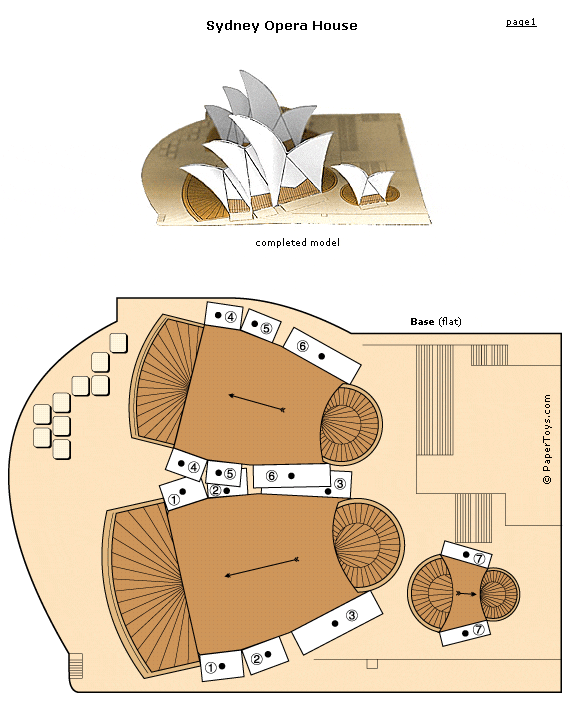
Paper Toys: Architecture to print and build

What it is:  At Anastasis Academy we have several kids who are absolutely crazy for architecture.  Not only can they emphatically tell you that they want to be an architect when they grow up, they collect architecture Lego models, will tell you how they wish they could go back in history to meet Frank Lloyd Wright and will build and draw models any chance they get.  These are elementary students!  Today when I came across these Paper Toy models of famous architecture, I knew I would have to share with our students and, while I was at it, would share with all of you who may have your own budding architects!

On Paper Toys you can find and print paper models for:

How to integrate Paper Toys Architecture Models into the classroom: In addition to instantly reaching hero status among your architecture crowd, the Paper Toys Architecture Models is a great addition to the math, history and art classroom.   Students can put the models together digging into the different architecture styles, mathematical models represented by the architecture, and the history of the architecture.  Students can print and build the models (a great exercise in patience, perseverance and attention to detail).  Next students can attach their finished model to a base where they can surround it with math, art or history details they learned about the building to the base.  If they really want to get creative, they can twirl and swirl the words around using different color markers to create an informative landscape.

Students can dig in further and map the various models on a Google map.  If several students are creating models, they can compare and contrast architecture from different time periods, different geographic regions and identify the origins of the type of architecture.

Tips:  Be sure to check out the other Paper Toy models. Your students can build cars, monuments and much more.  New models are added every month!

Please leave a comment and share how you are using Paper Toy Models in  your classroom!

Isle of Tune: Create a musical journey

What it is: Isle of Tune is a site that has just significantly impacted my productivity today- I can’t stop playing!  Thanks to @Matt_Arguello and @dancallahan for this share today on Twitter!  Isle of Tune lets students create musical journeys out of street layouts.  Roadside elements act as instruments and cars are the players.  Students can create whole islands of music by creating a street layout, adding objects that generate different sounds and adding cars to play the music.  Each object has an object panel where students can adjust the sound, volume or clone the object.  Students can determine when a sound will be played based on the ground lighting up when the car passes.  Junctions change the course of passing cars or can “loop” a sound.  It is easy for students to get started, they just click “Create a new island” and away they go.  Students can name their island anything and save to return to it later.  No need for registration, the Internet browser they are using just needs to have cookies enabled (this is a bit of a problem for shared classroom computers with a single account).

How to integrate Isle of Tune into the classroom: Isle of Tune is an enchanting place for creation.  The sky is the limit as students create music based on visual creation.  Aside from teaching some great music principles, Isle of Tune would be a fantastic way to teach students pattern.  Students can use Isle of Tune to construct patterns of objects and actually experience the connection between math and music as they “play” their pattern tune.

Isle of Tune would also be a fun place for students to learn about maps and ordinal directions and basic graphing.  Students can start with oral directions about where to lay their street “Four street squares North East, two street squares West”.  After directions are given, students can customize their islands with trees, houses, lamp posts, etc.  You can quickly tour the room for some formative assessment while students complete their island.  Let students take turns listening to each other’s Isle of Tune, noting similarities and differences based on the patterns made.

Use Isle of Tune as a creative writing prompt.  Students can create an island and tune and write an imaginative story about the island they created.  The saved island makes a nice visual-aid and soundtrack for their finished story.

Isle of Tune makes a great interactive whiteboard, or projector-connected computer activity.  Students can work together to create a giant island of tunes.  Use the annotate over the desktop feature to label directions, coordinates and patterns.

The shared songs are pretty incredible- many of the “top” shares are popular music that has been created using Isle of Tune.

Tips: Isle of Tune is currently available on the web, keep an eye out for the iPhone, iPod Touch and iPad versions coming soon!  If Isle of Tunes inspires your students to want to become architects or engineers, point them toward online CAD Drafting classes.

Please leave a comment and share how you are using  Isle of Tune in your classroom!

Cyberkidz: games for math, literacy, geography, creativity and science

What it is: Cyberkidz is a great new website packed full of great learning practice games for kids age 4 to 11.  The games reinforce skills in a variety of disciplines including math, literacy, geography, creativity and science.

Math– amounts, pattern, scale, number recognition, counting, scale, sums to 10, sums to 20, weights, multiplication, telling time, money, measurement, calendar, volume, percentage, distance, division, mathmix, area

Literacy– letter recognition, alphabetical order, hangman, crosswords, typing, singular and plural words, sayings and quotes, learning Spanish, learning Dutch

Geography– America, state capitals, countries of the world, Asia, Africa, France, Spain, Portugal, Belgium, Switzerland, Austria, Italy, South Africa, Ireland, flags

Creative– painting, music, coloring, maze

Science– food for animals, skeletal system, body parts, animals, solar system, mammals, the eye

The games in each category are great for practice and skill building.

How to integrate Cyberkidz into the classroom: Cyberkidz is a fun place for students to work on the knowledge level of Bloom’s Taxonomy.  The music game is the only creative game that I would truly place in the “create” category of Bloom’s Taxonomy because it gives students free rein to explore music and create a recording.   The majority of the games are designed to help students build skills and remember key concepts that are a necessary foundation for other learning.  These are a nice alternative to worksheet skill practice.  Students will enjoy the game quality of these practice activities.  Each activity can be advanced through relatively quickly making them perfect as a center on classroom computers.  Students can visit the game as a math, literacy, geography or science “practice” center before advancing to put those newly honed skills to work in a higher order thinking center.

These practice activities could also be completed as a class using an interactive whiteboard or projector connected computer.  Split students into teams and rotate them up to the whiteboard for a class practice session.

Tips: On each game screen, students can scroll to the bottom for instructions on the game.  Most of the games are pretty self-explanatory and kids will figure them out quickly.

Please leave a comment and share how you are using  Cyberkidz in your classroom!

Eyes on the Earth 3D

What it is: I’m still on my NASA/space kick, this time with Eyes on the Earth 3D from NASA.  This is a neat website that lets students track missions as they are happening with the satellites that are collecting information about the Earth from space.  Students can learn about the earth by choosing a mission to follow, zoom in and out of the globe, view satellite paths, view city and location labels on the map, replace the sun with an “artificial light” and see the view from Earth’s surface.  As students click on the satellite, they will be able to view and discover more information about the mission.  Students can choose to view the 3D Earth in real-time or speed up/slow down the Earth with a time control.  Students can choose to learn more at any time by viewing the official mission home page linked at the bottom of each page.

How to integrate Eyes on the Earth 3D into the classroom: This is a way for students to assume the role of NASA scientist to learn more about the Earth and collect data.  Students can view real data about sea levels, the Arctic sea ice minimum, carbon dioxide readings, global temperature and the ozone hole.  Students can study each mission to gain a better understanding of  what NASA scientists do and study.  If you teach younger students, the 3D globe is a great way to help students understand continents, oceans and earth rotation.

One of the features that I enjoy about Eyes on the Earth 3D is the ability to view the Earth from the satellite view or the satellite from the Earth view.  This will help young students better visualize and understand how satellites work and orbit the Earth.

If your students are studying satellites or NASA missions, assign each student a different mission to study in-depth.  Students can present what they have learned to the class as an oral presentation using the Eyes on the Earth 3D site as a visual.

Tips: Missions can be viewed by what their focus is: atmosphere, oceans or land.  If you are studying any of these, the missions would be a nice tie in.  Students can read or hear about all of this data but I think it is just as important to understand where it all came from and how it was collected.

Please leave a comment and share how you are using  Eyes on the Earth 3D in your classroom!


BrainNook: Virtual Learning World for Elementary Students

What it is: BrainNook is a virtual world for kids where they can develop math and English skills while playing in the free online playground.  There are over a hundred education games packed into the BrainNook virtual world, all of them are based on foundational math, English, and grammar concepts.  The math games cover concepts from single digit addition to 3D spatial visualization.  English games cover everything from building simple sentences to counting syllables.  The games are all woven into a fun virtual world that students can explore and unlock.  BrainNook also strengthens students reading, reasoning, decision-making skills, analysis, and computer literacy.  Students choose a character (alien) and name, when they enter BrainNook for the first time, they are dropped onto Earth where their spaceship has crashed. They are greeted by an earthling named Bella who teaches them how to navigate the world, and earn stars by playing games. The stars that are earned can be used to buy back spaceship parts.   Students can travel to several locations within the virtual world that are based on real-life regions of the Earth  Students learn about each region through trivia, question popups, and local artifacts. In each world students can play math and English games with other players in the safe online environment. As they build up their skills, new worlds will be unlocked and they can buy items from the local market or work on assembling their spaceship by assembling puzzles.  The games in BrainNook are scaffolded so it adjusts to students ability level as they progress.  Games can be played individually or in head-to-head competition. Because this site is geared toward elementary students, no personal information or personal messages are included in the virtual world.

How to integrate BrainNook into the classroom: BrainNook is a brilliant virtual world for elementary students in first through fifth grade.  The virtual world allows students to learn and practice math and English skills at their own pace, and at their own unique level.  The games are great for building and reinforcing foundational learning skills.  Because the game progresses as students do, students could continue on in their virtual world throughout their elementary school experience.  BrainNook is ideal as a computer lab activity or in a 1 to 1 situation.  If you don’t have time to use BrainNook as a virtual world for each student, consider signing up for an account yourself that can be used as a class account.  Review the games that match up with skills students are learning in class and have the whole class play the games using an interactive whiteboard or on classroom computers as a center.  Make sure to tell parents about BrainNook, this is a fun way for students to get extra math and grammar practice at home.

Tips: If students sign up for an individual account, they will need a parent’s email address validated before play.  BrainNook also has a school account option that you can learn about here.

Please leave a comment and share how you are using BrainNook in your classroom.

Tag Galaxy: Visual Word Relationships

What it is: Tag Galaxy is a neat little tool that helps students to explore relationships between words and ideas as well as view pictures related to that word.  Type in a word to search and immediately you are transferred to a galaxy with the original word at the center and the associated ideas orbiting around it.  When you click on the word in the center, a globe populates with pictures from Flickr that are tagged with that word. Click on one of the orbiting words and tags related to that word start to orbit.  Tag Galaxy is a very neat way to view information!

How to integrate Tag Galaxy into the classroom: Tag Galaxy is a brilliant way to visually  explore word relationships.  Students can use it to type in spelling or vocabulary words and discuss the relationship the related tags have to the original word.   Students can click on the original idea to get a visual understanding of the word in the form of a picture globe.  The connection with Flickr helps students to visualize words, ideas, and concepts by providing a variety of pictures that match the tag.  Tag Galaxy would make for a fun story starter.  Students can type in a word tag to get them started, view related words, and then click on the globe of pictures to spark creative writing ideas.  Tag Galaxy can be set up on classroom computers as a creative writing centers, or used for  whole class inspiration  with a projector-connected computer or interactive whiteboard.

Check out science, math, art, or geography vocabulary on Tag Galaxy, the resulting collection of images will help your students attach meaning to those tricky science concepts like my photosynthesis example above.

As a side note, Tag Galaxy also offers a pretty good visual aid for learning about orbit 🙂

Tips: ***Very important***  Whenever you are using tools that pull from other sites to populate, it is important to test out the words prior to using with students.  You never know how people will tag an image and the image might not be appropriate for all age groups.  When using Tag Galaxy with elementary students, have them suggest words that you test before using with the class.  In my classroom, whenever students wanted to do an image search, I had them fill out an “image wish list” first.  On the wish list students write down words they would like to search. I would do a quick test of the words and sign off on them.  This worked well as there were a lot of similar requests (i.e. animals!) 🙂

Please leave a comment and share how you are using Tag Galaxy in your classroom.

The Street: World Music

What it is: I am currently working on a fun project for Starrmatica tagging and organizing websites and resources.  One of the resources that was new to me is The Street: World Music.  This is a neat interactive learning journey from BBC radio where students can learn about other countries and cultures through music.  The Street features five families from five different countries including India, Ireland, Brazil, Turkey, and Nigeria.  In each house students can learn more about the country, instruments, musicians, religion, and food from the country.  Students have plenty of opportunities to listen to the music.

How to integrate The Street: World Music into your curriculum: Music is a neat way to introduce students to other cultures.  It allows an inside look into the culture by sharing the sounds of the culture.  What I like about The Street, is the way the music is introduced along side religion, food, and information about the country.  This site gives students a wonderful overview of five countries where they can not only read about the differences, but they can see the differences (through photos) and hear the differences (through music).  The Street is a great site to introduce into any classroom, music teachers will appreciate the look at the instruments and musicians of the country.  As an extension activity, have your students create their own “house” for The Street. This can be done offline with paper and a collection of music, photos, and information.  Alternatively use a website builder like Weebly or Wix or a Wiki to collect the information in an online space.  Students can choose a country to learn more about or create a house for their own country, thinking about what is important to their culture.  Want to extend the activity even more?  Connect with teachers from different countries and have the students learn about different cultures together.  Use Skype or Wetoku to connect the classes and play music from each culture.  Create a wiki together to collect and  share information learned.

Tips: If you are looking for teachers to collaborate  with, use and search the #glolab hash tag to connect.

Please leave a comment and share how you are using The Street: World Music in your classroom!

ArcGIS Explorer Online

What it is: ArcGIS Explorer Online is a neat mapping experience powered by BING that lets you use, create, and share ArcGIS (Global Information System) maps online.  The online software lets you read and write ArcGIS maps that can be used with the website, ArcGIS for the iPhone, and ArcGIS desktop version.  Mark up maps with notes that have photos, text, and links embedded directly in the map. Measure distances on the map and include them as a layer of the map.    Create a presentation in the map that guides viewers from one location on the map to another.

ArcGIS lets you create an interactive map experience.
1. choose a basemap to display your GIS data on top of.
2. Click on one of the map notes shapes to add a GIS note to your map.
3. Click "edit note" along the bottom of the note and add text, a picture, and a link.
Create a slideshow presentation of you map by clicking "Edit Presentation"
Click "Capture New Slide" to take a screen shot of your map to become a slide in the presentation.
Format the slide with the formatting tools above the map. View slides in the slide pane to the left of the map.
Click the home tab to return to the default tool bar. (You can switch back and forth between the two).
Click Measure to measure distances on the map. Click "add to map" if you want to add the measurement to the map.

How to integrate ArcGIS Explorer Online into your curriculum: ArcGIS Explorer is an impressive online mapping tool.  Use it to create guided tours for your students that can be played on classroom computers as an independent learning system or on the interactive whiteboard as a whole class map tour.  Embed links to informational websites, pictures relating to learning, and text to help guide your students through their journey.  Do one better by asking your students to create a map where they layer information, pictures, measurements, etc. on a map.  Students could create and swap tours of their home town with pen pals/blogging buddies around the world.  Create historical maps by adding notes with primary sources, pictures, links to additional learning (or blog posts that your students have written), and text that indicates the importance of the place.  Create literary maps by making note of key locations in literature that students are reading.  Students can add a note to the map with a quote from the book or a description of what happened there.  When they are finished reading, students can create a presentation/tour of the literature by creating a slide out of each place in the book.  An interactive literary tour of learning beats a traditional book report hands down!  ArcGIS would be a really neat way to plot a Flat Stanley project in the elementary classroom!

Tips: ArcGIS requires the Microsoft Silverlight plugin to work.  You can download Silverlight for free directly from the ArcGIS website.

Please leave a comment and share how you are using ArcGIS in your classroom!